Maps of rue Montorgueil
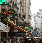
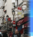
Located on the right bank of the River Seine within
the 2nd arrondissement of Paris the road runs roughly
north south with the southern end being just adjacent to
the Saint-Eustache church and Les Halles. Mostly
pedestrian in nature it runs north until it meets rue
R�aumur just less than 500 meters later. Close to the
theaters and operas as well as important museums and
government offices the area is a lively mix of
residential, cultural and professional.
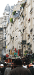
At the north end it merges seamlessly with the rue
des Petits Carreaux, which is part of the Montorgueil
area if not the road itself..
Google maps
Google Street view
Now take a virtual walking tour of
the area.
View Larger Map
Bing maps
In the Bing maps make sure to click the "Bird's Eye View" icon in order to have the best views.